Here are more streets with explanations as to how they were named:
Miller Street …Named for Alexander Clinton “Clint” Miller, a local financier who gave money to finance the local airport (called Miller Field and Miller Airport) and Miller Park. The air field was located in the same area as the Smith Reynolds Airport. The name was changed when the Reynolds family financed a terminal building that was named for Smith Reynolds. A. Clint Miller came to the city’s rescue when an air field was needed so that Charles Lindbergh could land there in 1927, during his multi-city flights. Read more about Clint Miller at http://winstonsalemtimetraveler.com/2014/04/02/april-2-happy-birthday/ and about the Miller Municipal Airport at http://winstonsalemtimetraveler.com/2014/09/03/september-3/
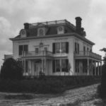
Patterson Avenue…The street was originally named Depot Street because the train depot was located on the street, in the downtown area. Part of the street was changed to Patterson Avenue about 1910, named for the Lindsay Patterson family who had a home on the street, located near 15th Street. The home was called “Bramlette.” Mrs. Patterson’s middle name was “Bramlette,” and she was a Patterson before she married Lindsay Patterson. Read more about Lucy Bramlette Patterson at http://winstonsalemtimetraveler.com/2014/08/22/august-22-happy-birthday-lucy-bramlette-patterson/
Patton, Wainwright, Eisenhower, MacArthur, Bradley, Arnold...You might say that the “brass” section is located off Lexington Road. These streets carry the names of American generals who served in World War II. George Patton and Jonathan Wainwright were 4-star generals. Dwight Eisenhower, Douglas MacArthur, Omar Bradley, and Henry Arnold were 5-star generals.
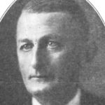
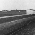
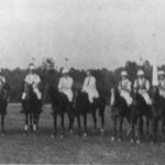
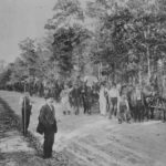
Polo Road…Named for the polo fields in the area near Speas School. The photos show the polo fields, the polo team, and Speas Elementary School under construction. The polo team participated in competitions with other polo teams, and the Winston-Salem team was comprised of many Hanes family members.
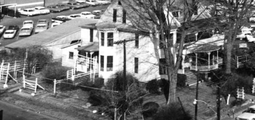
Reynolda Road…Named for the Richard J. Reynolds family who build an estate (Reynolda) on a road that was at the time north of Winston-Salem. The road was constructed so that the family and workmen could get to the property.
Rich Avenue…Probably named for D. Rich (1862-1924), the treasurer and a director of R. J. Reynolds Tobacco Company. Mr. Rich joined R. J. Reynolds Tobacco Company before the company was incorporated.
Ricks Street…Located near the former Hanes Mill Village and named for David Absalom Ricks (1877-1954). Mr. Ricks was superintendent and later general manager of the P. H. Hanes Knitting Company’s spinning plant. He and his family lived at Hanes, where the spinning plant was located. He retired after 25 years of service in 1945 because of poor health. He was a director of the company until his death in 1954. Ricks Street first appeared in the city directory in 1958, replacing the former “Main Street (Hanes).” The cross streets were numbered at that time, 2nd – 6th.
Roosevelt, Taft, Grant, Harrison, Lincoln, Garfield, Wilson (and probably others)…All named for United States presidents. The largest group of these “presidential” streets is located off Cherry-Marshall Expressway, near Paisley School.
Shattalon Drive…Here’s an interesting explanation of how Shattalon Drive was named:
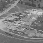
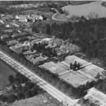
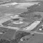
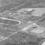
Shorefair Drive…The street name is a combination name reflecting its location and nearness to (former) Ernie Shore Field and the Dixie Classic Fairgrounds. The aerial photographs show the new Ernie Shore Field, the racetrack at the fairgrounds, and the Memorial Coliseum. Shorefair Drive is near the bottom of both images.
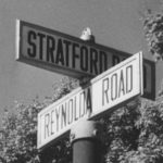
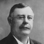
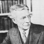
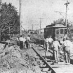
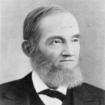
Sprague Street…Named for Frank Julian Sprague (1857-1934), inventor of the Sprague electric motor which ran all the streetcars in town. He was known as the “Father of Electric Traction.” The streetcar line ran in the area of Sprague Street. The photos below show Mr. Sprague, and Sprague Street being paved near the intersection of Sprague Street and Thomasville Road about 1925.
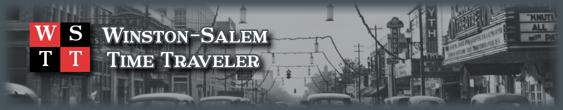
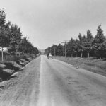
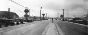
Stratford Road…The area known as South Stratford Road was called the Clemmons Highway or Clemmons Road. The name “Stratford Road” first appeared in the city directory about 1928, referring to the north part of Stratford Road. There were two residences on N. Stratford Road in 1928 – G. S. Norfleet (330) and C. V. Strickland (414). The coming of Interstate 40 and the Thruway Shopping Center quickly made this area of town very attractive to businesses and shoppers. The photo below shows South Stratford Road looking toward Thruway in 1958. The A&P Grocery Store and Farmers Dairy Bar are at left and the Howard Johnson Motel and Restaurant are at right.
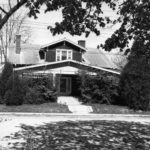
Sunnyside Avenue…Named for Sunnyside Dairy that was once in the area. On the street was also the home of Dr. Douglas Rights, Moravian minister who was pastor of Trinity Moravian Church and the parsonage was located at 2323 Sunnyside Avenue. The parsonage is shown below in 1948.
Trade Street…The original name for this street was Old Town Street because it led to the “old town,” which was Bethabara. The name was changed to Trade Street to reflect the tobacco trade that was conducted from the 400 block and north of Fourth Street. The tobacco trade brought business to other retail establishments along the street, such as stables, cafes, boarding houses, and hardware stores.
Vintage Avenue…Legend says that the street was named for a reclusive chemist who lived there and owned a vineyard in the area. He apparently concocted a solution that exploded and killed him.
Wiley Avenue…Named for Calvin H. Wiley, the first school superintendent in North Carolina and the man for whom Wiley School was named. There is also a monument for him on the Wiley School grounds. The monument first stood near Broad Street and West Fourth Street, where the West End School was located. When the school was demolished, the monument was moved. Wiley Avenue is located near R. J. Reynolds High School. To read more about Calvin Wiley, see http://winstonsalemtimetraveler.com/2014/02/03/february-3-happy-birthday-calvin-henderson-wiley/
Yale, Harvard, Cornell…Named for universities; located off Lexington Road
Do you know of a street that was named for an individual and not on this list? If so, please comment.
Stay tuned for the next historical post on August 15th featuring West Forsyth High School.
Photos courtesy of Forsyth County Public Library Photograph Collection.

Butler street was named for a prominent African American wagon maker in Waughtown.
There used to be a street named for the Ivester family, but that land was taken for the Forsyth
Tech building closest to Miller street. One of my relatives lived there.
Anyone have info on Forest Hills neighborhood? Grew up on Clayton St.